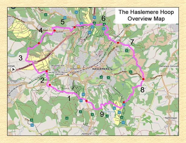
THE HASLEMERE HOOP
A walk devised by Neil Hook
Planning Your Walk
A map for each leg is included with the leg route description
Neither the author nor the website administrator accepts responsibility for any missing signposts or waymarks or other changes to the route beyond their control.

Leg1 Kingsley Green to Linchmere Common (2.8 km)
|
Start Point (and finish for Leg 9) |
Kingsley Green on Midhurst Road (A286) at the junction with Hatch Lane. |
|
Distance from station |
3km |
|
Bus Links from Haslemere Station |
#70 bus stops on Midhurst Road (A286) about 150m before the junction with Hatch Lane |
|
Car Parking |
None. There is a lay-by about 750m along Midhurst Road (A286) on L. Nearest public car park off Midhurst Road (S) in Fernhurst (about 2.5km). |
|
Nearest Pub to Kingsley Green |
The Red Lion, Fernhurst (https://www.red-lion-fernhurst.co.uk/) and car parking (2.2km). Turn L from Hatch Lane (S) and follow Midhurst Road to sign L to Red Lion at Hogs Hill. |
Leg 2 Linchmere Common to Hammer Vale (1.25 km)
|
Start Point (and finish for Leg 1) |
Linchmere Road at the entrance to Linchmere Common about 500m from junction with Liphook Road (B2131). |
|
Distance from station |
3.4km |
|
Bus Links from Haslemere Station |
#504 bus stops on Linchmere Road at junction with Liphook Road (B2131). #13 bus stops on Linchmere Road (B2131) at Heath Road about 500m from this junction (SW). |
|
Car Parking |
Off-road car parking on both sides of Linchmere Road. |
|
Nearest Pubs to Linchmere Common |
The Prince of Wales, Hammer Vale (https://www.princeofwaleshaslemere.co.uk/) (1.25km) [end of next leg]. Or The Mill, Shottermill (https://www.themillhaslemere.co.uk/) (1.7km). Follow Linchmere Road towards Haslemere and turn L at Shottermiill. |
Leg 3 Hammer Vale to Waggoner's Wells (3.65 km)
|
Start Point (and finish for Leg 2) |
The Prince of Wales, Hammer Vale |
|
Distance from station |
3.4km |
|
Bus Links from Haslemere station |
#70 bus stops on B2131 Linchmere Road – turn R into Hammer Lane and L at Hammer Vale. The Prince of Wales is on R about 15 mins walk from the bus stop. |
|
Car Parking |
Customer car park at pub. |
|
Nearest Pub to Hammer Vale |
The Prince of Wales [start of this leg]. |
Leg 4 Waggoner's Wells to Grayshott (1.75 km)
|
Start Point (and finish for Leg 3) |
Waggoner's Wells car park (https://www.nationaltrust.org.uk/ludshott-commons/features/waggoners-wells). |
|
Distance from station |
8.3km |
|
Bus Links from Haslemere station |
#23 bus stops on Headley Road (B3002) in Grayshott – turn L into Waggoner's Wells Road. Car park is about 15 mins walk from bus stop. |
|
Car Parking |
Free visitors' car park. |
|
Nearest Pub to Waggoner's Wells |
The Fox and Pelican, Grayshott (https://www.foxandpelican.co.uk/) (1.75km) [end of this leg]. |
Leg 5 Grayshott to Hindhead (2.55 km)
|
Start Point (and finish for Leg 4) |
The Fox and Pelican, Headley Road (B3002), Grayshott |
|
Distance from station |
5.65km |
|
Bus Links from Haslemere station |
#23 bus stops on Headley Road (B3002) almost opposite Fox and Pelican. |
|
Car Parking |
Customer car park; Headley Road car park 50m R just before war memorial. |
|
Nearest Pub to Grayshott |
The Fox and Pelican [start of this leg]. |
Leg 6 Hindhead to Grayswood (3.65 km)
|
Start Point (and finish for Leg 5) |
The Devil's Punchbowl Hotel, London Road (old A3), Hindhead |
|
Distance from station |
4km |
|
Bus Links from Haslemere station |
#18 and #19 bus stops on old Portsmouth Road (A333) about 250m before car park. |
|
Car Parking |
Customer car park at Hotel; National Trust car park opposite Hotel. |
|
Nearest Pub to Hindhead |
The Devil's Punchbowl Hotel [start of this leg]. |
Leg 7 Grayswood to Ansteadbrook (3.55 km)
|
Start Point (and finish for Leg 6) |
The Wheatsheaf (http://www.thewheatsheaf.grayswood.co.uk/), Grayswood Road (A286), Grayswood. |
|
Distance from station |
2.8km |
|
Bus Links from Haslemere station |
#70 bus stops on Grayswood Road (A286) opposite All Saints church. |
|
Car Parking |
Customer car park; some parking on Lower Road R off Grayswood Road about 150m past pub (NE). |
|
Nearest Pub to Grayswood |
The Wheatsheaf [start of this leg]. |
Leg 8 Ansteadbrook to Black Down (2.55 km)
|
Start Point (and finish for Leg 7) |
Petworth Road (B2131), Ansteadbrook near junction with Rogate Lane (B2131). |
|
Distance from station |
4km |
|
Bus Links from Haslemere station |
#71 buses are said to stop on request . Nearest bus stop on Petworth Road at Almshouses (2.2km NW) on steep and busy road with few walkways. |
|
Car Parking |
None. Nearest car parks in Haslemere centre (3.5km). |
|
Nearest Pubs to Ansteadbrook |
The Mulberry Inn, Petworth Road (A283), Chiddingfold (https://themulberryinn.co.uk/) and customer car park (1.8km). Follow Rogate Lane (B2131) (NE) and L on Cripplecrutch Hill (A283). Pub is on R. Or The Lythe Hill Hotel, Petworth Road (B2131) (https://www.lythehill.co.uk/) and customer car park (about 1km) along Petworth Road (NW). |
Leg 9 Black Down to Kingsley Green (3.25 km)
|
Start Point (and finish for Leg 8) |
Black Down (https://www.nationaltrust.org.uk/black-down) information board on track leading S from Tennyson's Lane car parks about 250m past National Trust marker (sp). |
|
Distance from station |
3.3km |
|
Bus Links from Haslemere station |
None |
|
Car Parking |
National Trust car parks at Tennyson Lane. |
|
Nearest Pubs to Black Down |
The White Horse (https://www.thewhitehorsehaslemere.co.uk/) Or The Swan (https://www.classicinns.co.uk/swaninnhaslemere) in Haslemere town centre about 2.7km along Tennyson Lane (NW). Public car park nearby. |